Top 11 Must-Do Hikes In California, USA
The “Golden State” of California is the most populous and third-largest state by area in the United States and is a popular destination for hikers worldwide. California’s vast terrains make for a wide range of hiking opportunities, from the beautiful mountain ranges to the forest to the desert to the Pacific coast. There are plenty of excellent hikes to choose from, including the many in the world-famous Yosemite national park.
Among so many superb hiking trails, some stand out as must-dos. Whether you’re visiting California for the first time or you are a permanent resident, we’ve assembled a list of what we believe to be the 11 must-do hikes in the state.
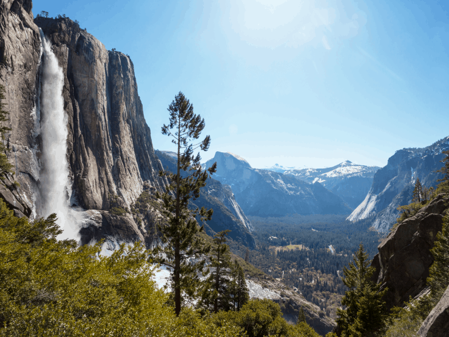
Yosemite Falls Trail (Upper & Lower)
Yosemite National Park
Upper Falls Trail
Distance: 12.2 km // 7.6 miles (out and back)
Time: 6 – 8 hours
Difficulty: Hard
Lower Falls Trail
Distance: 1.9 km // 1.18 miles (loop)
Time: 30 minutes to an hour
Difficulty: Easy
The Yosemite Falls Trails draws in hikers and tourists alike to see one of the tallest waterfalls in North America. Whether hikers take the easy Lower Falls Trail or the more challenging Upper Falls Trail, both give jaw-dropping views of the 2,425-foot waterfall.
If you are looking for a short and relatively easy trail, then the Lower Falls Trail is the one for you. The trail is wide, flat, and has only a few inclines. The first half of Lower Falls Trail is both accessible and stroller-friendly.
The Upper Yosemite Falls Trail is quite challenging. Hikers should prepare to climb. With 135 switchbacks and around 2,700 feet (823 m) of elevation gain, this is a gruelling hike with a worthwhile view at the top.
From the top of Yosemite Falls Trail, hikers can extend their hike onto Yosemite Point or to Eagle Peak. Yosemite Point is an additional 2.6 kilometres (1.6 miles roundtrip) and offers the second-best viewpoint of Half Dome.
While Eagle Peak is an additional 9.3 kilometres (5.8 miles round trip), Eagle Peak is a part of the Three Brothers rock formation and is the highest point in the Warner Mountains and Modoc County.
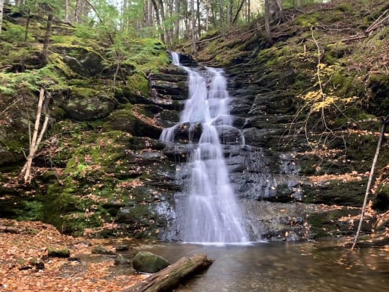
McWay Waterfall Trail
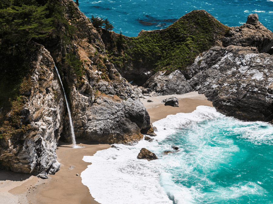
Julia Pfeiffer Burns State Park
Distance: 1.9 km // 1.2 miles (out and back)
Time: 30 minutes to an hour
Difficulty: Easy
McWay Waterfall Trail is a quick 1.2-mile out-and-back hike that is suitable for all-level hikers. While this is an easy trail, it is the perfect place to get out and stretch your legs as you make your way along Big Sur Coast. This breathtaking lookout features an 80-foot-tall (24 meters) that flows onto a picturesque beach in McWays Cove.
There are two ways to reach the McWay Waterfall Trail. The first is by parking off of Highway One. This option is free.
The second option is to pay for parking in Julia Pfeiffer Burns State Park. This option is a bit further of a walk. However, it is great for those who want to spend more time in the park and explore additional trails. Julia Pfeiffer Burns State Park also features an accessible trail that leads to the McWay Waterfall lookout.
For safety reasons, you cannot go down to the cove. You must admire the falls from the designated trails. Rangers are patrolling the area, and hikers may get fined if they attempt to descend to the cove.
Eagle Falls & Eagle Lake Trail
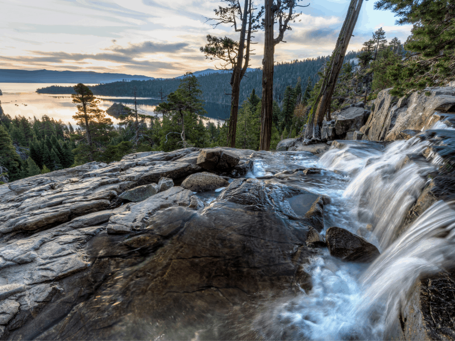
Desolation Wilderness
Distance: 3.9 km // 2.4 miles (out and back)
Time: 2-3 hours
Difficulty: Moderate
Eagle Falls and Eagle Lake Trail offer some of the most incredible views that Lake Tahoe has to offer. Hiking to Eagle Falls is great for all-level hikers. It poses a bit of a challenge, starting with a rock stairway that leads to a breathtaking waterfall with a bridge that goes over it.
If you are not in the mood for a full day of hiking, hikers can turn around here. However, if you want to keep hiking, continue past the waterfall onto the Eagle Lake Trail.
Once you reach Eagle Lake, prepare for an awe-inspiring view of the mountainscape reflecting onto the lake. This is a great spot to sit back, relax and enjoy the view before returning back down the trail.
If you choose to hike all the way to Eagle Lake, you will need to pick up a Desolation Wilderness permit at the trailhead.
John Muir Trail

Yosemite National Park
Distance: 339.6 km // 211 miles (point-to-point)
Time: 3 weeks
Difficulty: Hard
Now, the John Muir Trail is not for the faint of heart or inexperienced hikers. This world-famous hike covers 339.6 kilometres from Yosemite Valley to Mount Whitney, the tallest mountain in the contiguous United States with an elevation of 14,505 feet.
Most people complete the John Muir Trail in around three weeks. This hike takes preparation and planning before beginning, including re-supply spots. Since you will be on the trail for around three weeks, you will likely need to stop in nearby towns to re-supply 3-4 times.
With 46,000 feet of elevation and crossing six high elevation mountain passes, this trail offers some of the best mountain scenery in the United States.
Not just anyone can hike the John Muir Trail. A permit is needed to hike this trail, which is quite challenging to obtain. According to the national park service, 97% of JMT permits get denied. But, do not let this discourage you from applying for this once-in-a-lifetime hiking experience.
Be prepared to apply at least 24 weeks in advance for a permit. The number of permits has been limited to reduce environmental impact.
49 Palms Oasis Trail
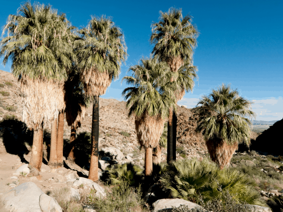
Joshua Tree National Park
Distance: 5 km // 3.1 miles (out and back)
Time: 2-3 hours
Difficulty: Moderate
49 Palms Oasis Trail is a heavily tracked trail featuring rocky ridges and an incredible desert oasis. The trail starts with a slight incline up the ridge, offering views of the dessert. The trail itself can become rocky at times and has little to no shade until you reach the oasis.
When you begin to descend into the oasis located in a rocky canyon, there is spring surrounded by beautiful California fan palm trees and large boulders at the oasis. This is a great spot for hikers to take a break and enjoy a snack while taking in the scenery.
Gaining 300 feet of elevation on the trail, hikers should come prepared with enough water, sunhats, and sunscreen. It is also recommended to avoid hiking in the summer due to the heat. If you are looking for a bit of a longer hike, then the Lost Palms Oasis is the hike for you!
This hike is also located in the Joshua Tree National Park and spans 11.6 kilometres out and back (7.2 miles). The Lost Palms Oasis offers similar terrain to the 49 Palms Oasis and leads down to a canyon featuring California fan palm trees.
Lost Coast Trail
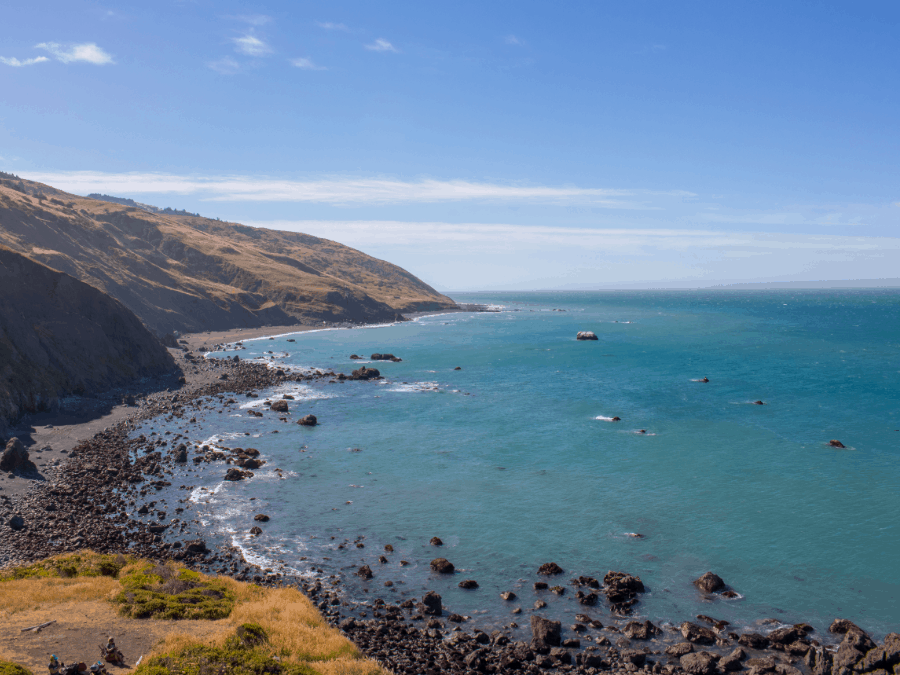
King Range Wilderness
Distance: 40.7 km // 25.3 miles (point-to-point)
Time: 3 – 4 days
Difficulty: Moderate
The Lost Coast Trail is a challenging multi-day hiker that is not recommended for beginner hikers. Apart from the sea lions, hikers are practically in solitude. The Lost Coast Trail is so rough that roads and developers have left it alone. Making this trail the perfect escape from the fast-paced city and noise.
Because this is a point-to-point hike, you will need a shuttle car at the end of the hike to take you back to the beginning. Hikers should come prepared with the necessary hiking gear and camping gear, including a water filter and either a GPS or map, as service can be limited along the trail.
A permit is needed to camp overnight on the Lost Coast Trail, and all hikers must have at least one bear canister per person.
Muir Woods
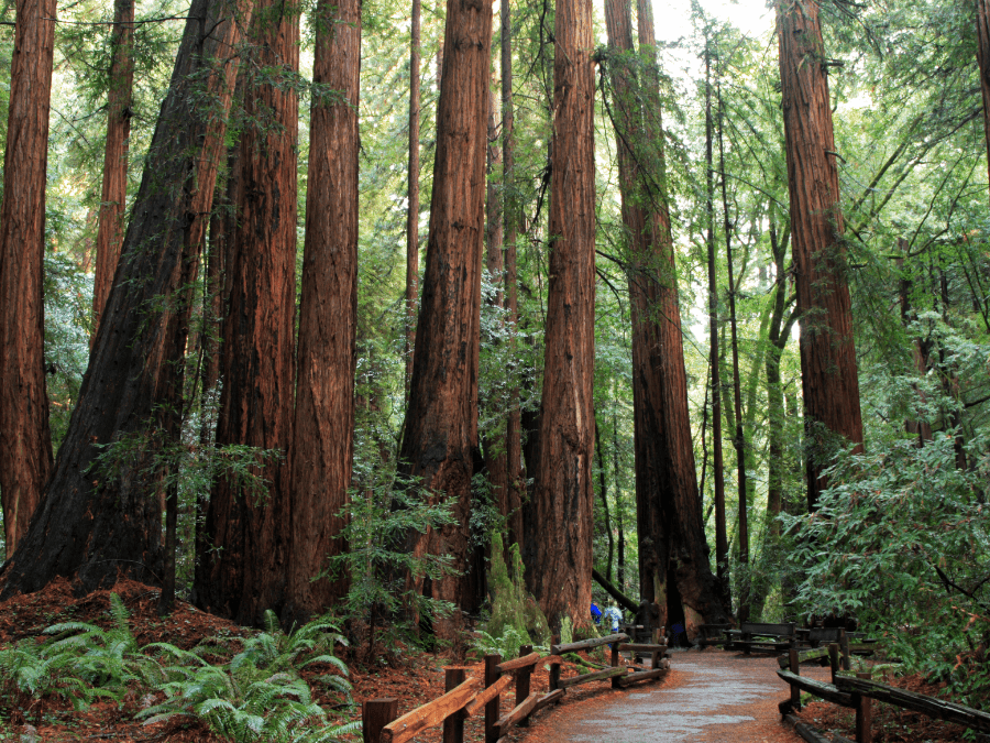
Muir Woods National Monument
Distance: 6.3 to 18.5 km // 3.9 to 11.5 miles
Time: 2-5 hours
Difficulty: Easy to Moderate
Muir Woods is an easy to moderate series of trails taking hikers through groomed terrain surrounded by coast redwoods. These trees are the tallest living things on Earth. Named after John Muir, Muir Woods is the first National Monument that was solely created by a land donation from Congressman William Kent. He did this in an act to protect the redwoods from the logging industry.
Over the years, Muir Woods National Monument has become quite a tourist destination, attracting thousands of visitors per day. Parking can be limited due to the amount of popularity. There are also shuttle and tourist buses available.
Muir Woods is day-use only. There is no camping or lodging permitted. However, there are camping facilities nearby for those who wish to stay nearby. Picnicking and pets are not permitted.
Four Mile Trail

Yosemite National Park
Distance: 14.8 km // 9.2 miles (out and back)
Time: 5-8 hours
Difficulty: Hard
The Four Mile Trail is a difficult trail that is recommended for experienced hikers. Featuring various switchbacks along the way, this trail offers the best views of Yosemite Valley.
Originally, the trail was built in 1872 as a toll road to connect Yosemite Valley and Glacier Point. Now, it is a popular destination for hikers and tourists.
The Four Mile Trail ends at Glacier Point. Here there are restrooms, a parking lot, and a snack shack (summer only). The area tends to get a bit crowded as there are three tour buses a day that all stop here.
Hikers can opt to take the tour bus back down to Yosemite Valley, though tickets are limited and need to be purchased in advance. Note there is no free shuttle from Glacier Point to Yosemite Valley.
From Glacier Point, hikers can turn around and return to Yosemite Valley, continue on Panorama Trail or arrange for a ride back from Glacier Point. On the return trip back from Glacier Point, hikers will see views of Half Dome, Tenaya Valley, Yosemite Falls, El Capitan, and western Yosemite Valley.
Lembert Dome
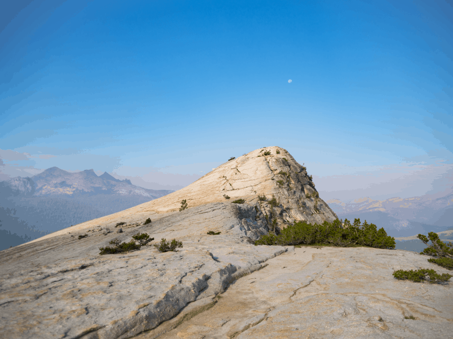
Yosemite National Park
Distance: 6 km // 3.7 miles (out and back)
Time: 2-3 hours
Difficulty: Moderate
Lembert Dome Trail is a fairly easy hike that climbs up a mountain, offering a 360 view of Tuolumne Meadows from the top.
While the hike is up a mountain, the ground is relatively flat and wide, making for an easier hike that does not feel overly crowded. This hike is also less popular than others in the Yosemite national park, making it a perfect trip into nature.
So whether you’re an experienced hiker or you’re just getting yourself into hiking shape, this trail is a great day trip. With an elevation gain of 900 feet, this relatively short trail will surely get your heart pumping. Trek upward safely on the backside of the dome and enjoy the lookoff. We promise the view is well worth your troubles!
Kelso Dunes Trail

Mojave National Preserve
Distance: 4.3 km // 2.7 miles (out and back)
Time: 1.5-2.5 hours
Difficulty: Moderate
Kelso Dunes Trail is roughly a 3-mile out-and-back trail full of sand and beautiful views of dunes and peaks in Mojave National Preserve.
The trail starts with a clearly marked trailhead, which begins to disappear the further you go into the trail. Due to the wind constantly reshaping the sand, it isn’t easy to keep a clear trail.
To help hikers avoid getting lost when the trail becomes obscure, we recommended either a GPS, map, or look for the summit and continue towards it.
As you begin to make your way up or down the slopes, you may hear a “booming sound” beneath your feet. This is called “singing sand, ” triggered by wind passing over dunes or walking on sand.
While this hike is rated moderate, it is more towards the difficult side as walking on sand can be strenuous. There are no sources of water or shaded areas. Hikers should come prepared with ample enough water and sunscreen. It is also recommended to go in the coolers months, early mornings or late afternoon.
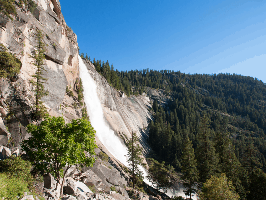
Mist Trail

Yosemite National Park
Distance: 4.8 km // 3 miles (roundtrip to Vernal Falls), 11 km // 7.2 miles (roundtrip to Nevada Falls)
Time: 2-5 hours (depending on trails)
Difficulty: Moderate
Mist Trail is one of the most popular trails in Yosemite National Park and California. The trail features various breathtaking views, including two incredible waterfalls: Vernal Falls and Nevada Falls.
There are two ways to reach the Mist Trail trailhead. The first is walking from Curry Village, which will add an extra 1.5 miles (2.4 kilometres) round trip. The second option is to catch a shuttle bus to the trailhead.
To reach Vernal Falls, you will need to climb a 600-step granite stairway. This can be quite slippery due to the mist from the falls (hence where the trail gets its name). At the top of Vernal Falls, hikers can take in the view, which looks down the 317-foot waterfall. From here, hikers can either return the way they came or continue to Nevada Falls. To get to Nevada Falls, hikers will go through steep switchbacks until they reach the 594-foot waterfall.
The Mist Trail ends with another junction of the John Muir Trail. The return segment back to the Mist Trail trailhead is on the John Muir Trail, which gives hikers striking views of Liberty Cap and the back half of Half Dome.