Top 11 Must-Do Hikes in Nova Scotia, Canada
Dubbed Canada’s Ocean Playground, the province of Nova Scotia is home to several excellent hikes characterized by glacial rocks, thick Acadian forest, and plenty of lakes. Hike along with coasts of the Gulf of Saint Lawrence to the north, the Bay of Fundy to the west, the Gulf of Maine to the southwest, and the Atlantic Ocean to the east. You can also venture into the vast wilderness inland from the coast or take a boat out to one of the many islands for an unforgettable hiking experience
Though there are plenty of excellent hikes in Nova Scotia, we’ve assembled a list of our top 11 must-do hikes for visitors and residents alike.
Completing the hikes mentioned above will take you to various parts of the province. Most of these hikes can be completed in a day trip from the capital city of Halifax. Additionally, two of these hikes are situated off the famous Cabot Trail in beautiful Cape Breton.
With that introduction, let’s get into the top 11 must-do hikes in Nova Scotia!
The Bluff Wilderness Trail
Timberlea, NS
Distance: 9km to 29km (4 loops)
Time: 2-8+ hours
Difficulty: Hard
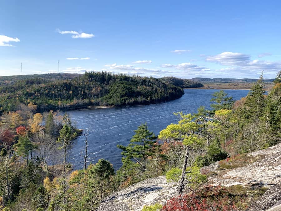
The Bluff Wilderness Area has four hiking loops, each with its own unique characteristics and varying levels of difficulty. The terrain differs throughout each loop and ranges from a quick 2-4 hour hike to a full day or even an overnight hike. To help prevent hikers from getting lost, each of the four loops is clearly marked with different coloured markers.
The first and shortest loop is the Pot Lake Loop, which is 9 km long and takes around 2-4 hours to complete. As the most popular loop, it’s also the busiest. The next loop is the Mi’kmaq Hill Loop, a 17.4 km hike that can take up to 6 hours to complete. The third loop is the Bluff Loop, which is 23.4 km long and can be quite tricky due to the mixed terrain. Finally, the Hay Marsh Loop is the longest trail, taking just over 29 km to complete. While it’s possible to complete it in one day, many hikers choose to camp midway along the trail and complete it within two days.
Trailhead Access
A parking lot is located at 2890 St. Margaret’s Bay Road, Timberlea. To access the trailhead, you must walk a half kilometre on the Beechville-Lakeside-Timberlea (BLT) trail.
For more information on Bluff Wilderness Trail, check out our article “Hikers’ Guide To The Bluff Wilderness Trail, NS”.
Cape Split
Cape Split Provincial Park Reserve, Kings County, NS
Distance: 13.2 km (loop)
Time: 3-4 hours
Difficulty: Moderate
Cape Split is one of the most popular hiking trails in Nova Scotia due to it being well-maintained, easy-to-follow and let’s not forget about the stunning lookoff onto the Bay of Fundy. Recently, the Provincial Park has been expanded,t and a second trail named the Scot’s Bay Trail has been added. This new trail connects with the previous trail, now renamed the Minas Basin Trail, creating a 13.3 km loop with numerous lookout points on both trails.
The trail is rated moderate as it is a gradual incline up the split, but it is not excessively challenging and provides a good workout. Although the trail is well-maintained, it can be muddy at the start, particularly after rainfall or during spring snowmelt. Therefore, we recommend wearing comfortable and waterproof
The lookout is the perfect spot for hikers to take a break and enjoy their lunch while admiring the stunning view. It is important to stay away from the edge of the cliffs since they are constantly eroding.
For more information on Cape Split, check out our article “Hikers’ Guide To Cape Split, NS”.
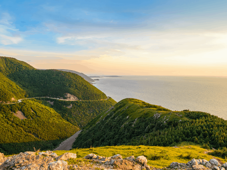
Skyline Trail
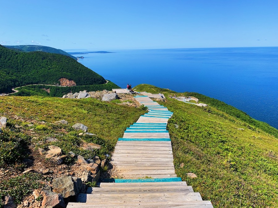
Cape Breton Highlands National Park, NS
Distance: 6.5 km (return); 8.2km (loop)
Time: 1.5 – 3 hours
Difficulty: Easy
The Skyline Trail in Cape Breton offers one of the most breathtaking views of the Cabot Trail and the Gulf of St. Lawrence. It is conveniently located just off the Cabot Trail and provides an excellent opportunity to take a break from driving and enjoy the stunning beauty of Cape Breton.
When hiking the Skyline Trail, you will have two options. The first option is an out-and-back trail, which is the shortest of the two. The second option is the entire loop, which is just over 8 kilometres long. Most of the trail is well-groomed, with crushed rock, and there are very few elevation changes.
The out-and-back trail is a leisurely stroll rather than a challenging hike. Both trails begin at the same trailhead. Hikers can either return the way they came or turn right off the trail to complete the full loop after they reach the iconic lookout.
If you choose to take the loop option, you will have a higher chance of spotting some wildlife, like moose. However, it’s worth keeping in mind that this trail can be a bit more challenging, as it includes a few inclines and offers little shade. Be sure to prepare yourself for direct sunlight during certain sections of the trail.
For more information on the Skyline Trail, check out our article “Hiking the Skyline Trail: Cape Breton Highlands National Park”.
Pollett’s Cove
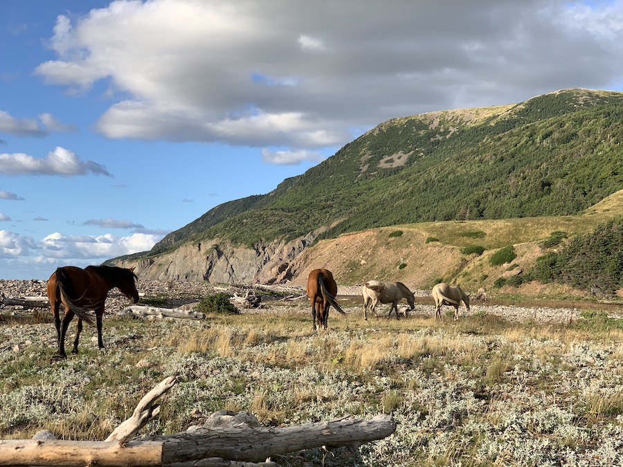
Apsey Fault Wilderness Area, NS
Distance: around 16 km (out and back)
Time: 6-8 hours (option to camp at the cove)
Difficulty: Hard
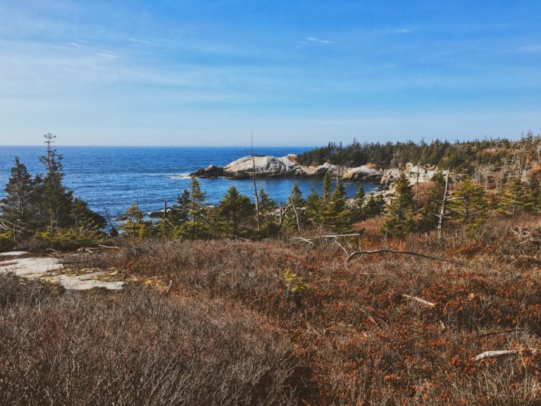
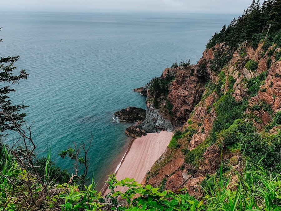
We believe that the Pollett’s Cove hike in Cape Breton is one of the most awe-inspiring trails in Nova Scotia. At the start of the hike, you’ll face a steep 1.8 km climb that’ll surely get your heart racing. However, once you make it to the cove and witness the sight of wild horses roaming about, you’ll realize that all the sweat (and perhaps some tears) was worth it.
The hike to Pollett’s Cove can be completed in one day, but many hikers choose to camp overnight at the cove before hiking back.
Pollett’s Cove trail is owned by Matthew Moore, a local lottery winner, who graciously allowed public access to his property. Hikers are expected to be respectful towards the property and wildlife in the area. Please remember to leave no trace behind and do not litter or cause any damage or harm to the environment or the horses.
Getting There
Follow the Cabot Trail until you reach Pleasant Bay. Turn onto Red River Road and follow
For more information on Pollett’s Cove, check out our article “Hiking Pollett’s Cove (Cape Breton, NS)”.
Franey Mountain
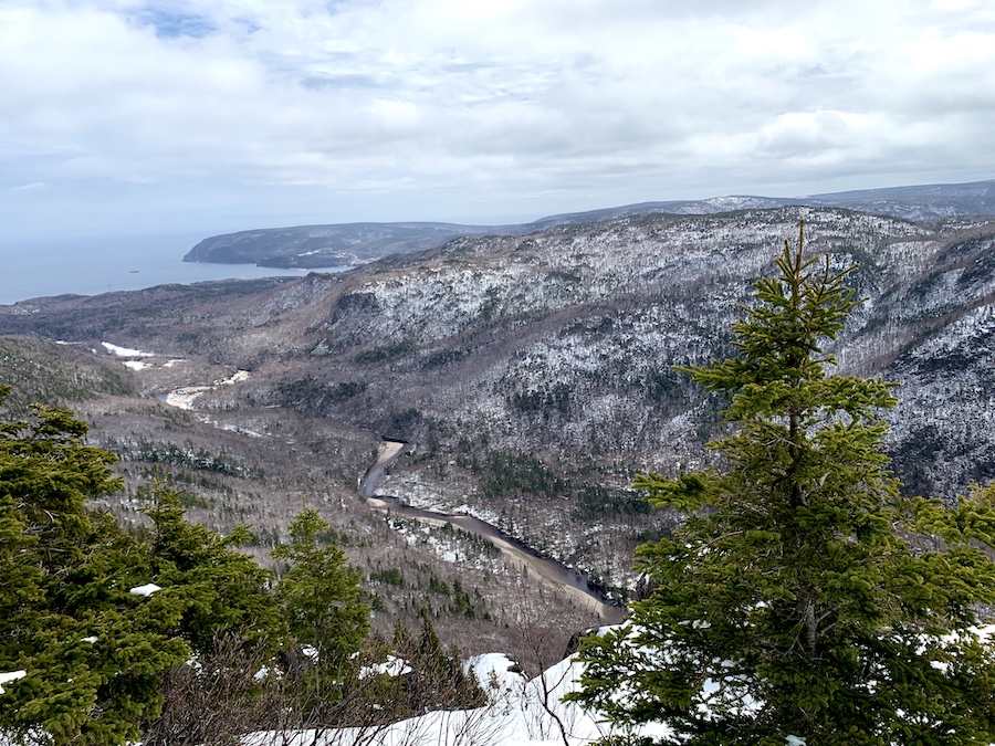
Victoria County, Cape Breton, NS
Distance: 7.4 km
Time: 2-4 hours
Difficulty: Moderate to hard
Franey Mountain is a popular hiking trail in Cape Breton Highlands National Park. The trail takes you through the Acadian forest on a steady climb, leading to a breathtaking panoramic view of Clyburn Brook Canyon and the Atlantic coastline from Cape Smokey to Ignonish.
The Franey Mountain trail is beautiful regardless of the season you choose to go. It is particularly popular in summer and fall when the leaves in Cape Breton transform into a beautiful sight to see. In springtime, the mountain may still have some snow but don’t worry, the trail is still doable. However, we recommend bringing snowshoes just in case to prevent sinking in the snow. We went at the end of April and found ourselves knee-deep in snow, but it was still a fun hike, and the views were just as stunning! We spotted various wildlife prints in the snow, including those of coyotes, moose, and bears. Keep an eye out; you might catch a glimpse of some wildlife.
For more information on Franey Mountain, check out our article “Hikers Guide To Franey Mountain (Cape Breton, NS)”
McNabs Island
Halifax Regional Municipality, NS
Distance: 18 km of trails
Time: 4-8 hours (option for overnight stay)
Difficulty: Easy to Moderate
McNabs Island is a great destination for those who want to take a break from city life. Located just a 30-minute boat ride away from Halifax, it offers a unique opportunity to explore the woodlands and shoreline while enjoying the view of the city across the water. Along the 18 km of trails, you can also learn about the history and settlement of McNabs Island. It’s a fun and educational experience that you won’t want to miss!
To reach McNabs Island, visitors have two options: taking a private boat or commercial service from Halifax, Dartmouth, Eastern Passage or Northwest Arm. McNabs Island is an ideal spot for educational visits, hiking the Garrison Road – which stretches across the entire island – or camping overnight if you’ve obtained a permit.
When planning a day trip to McNabs Island, it’s important to note that there is no access to clean drinking water. Hikers should bring enough water and snacks for a day hike or overnight stay.
Musquodoboit Trailway
Halifax Regional Municipality, NS
Distance: 15 km (oneway)
Time: 6 – 7 hours
Difficulty: Easy
The Musquodoboit Trailway is an amazing trail system that connects to several backcountry trails. It was previously a railway and is now a well-maintained 15-kilometre one-way trail. The trail is easily accessible and suitable for strollers. It is also a favourite spot for dog walkers, but dogs must always be kept on a leash.
If you’re interested in backcountry hikes, you should definitely check out the Musquodobout Trailway. You can access five different trails off of the main trail, which are quite fun to explore. These trails offer a variety of terrains, including some steep inclines and stunning views.
The trails include Gibraltar Rock (Skull Rock) Trail, Admiral Lake Trail, Bayer Lake Trail, South Granite Ridge Trail, and North Granite Ridge Trail. All these trails are day hikes only. Camping and fires are not permitted on any of the loops. Hikers should prepare accordingly for each hike. It is important to bring enough water, snacks, and proper hiking boots.
For more information on the five aforementioned backcountry loops, check out the following Hikers’ Movement articles:
• Hiking To Skull Rock, Musquodoboit Harbour (NS, Canada)
• Hiking Admiral Lake Loop, Musquodoboit Harbour (NS, Canada)
• Hiking Bayer Lake Loop, Musquodoboit Harbour (NS, Canada)
• Hiking South Granite Ridge Trail, Musquodoboit Trailway
• Hiking North Granite Ridge Trail, Musquodoboit Trailway
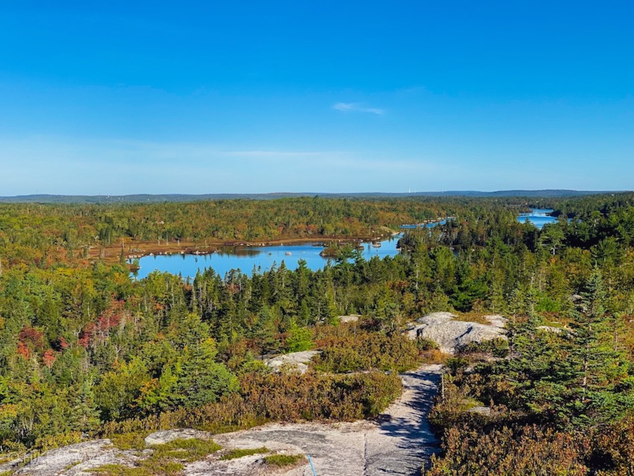
Kearney Lake Trail / Blue Mountain Birch Cove Lakes
Blue Mountain Birch Cove Lakes Wilderness Area, NS
Distance: 2.9 km to 9.3 km (varies depending on the trail)
Time: 1 – 5 hours
Difficulty: Difficult
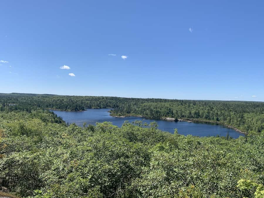
The Kearney Lake trails were once a system of trails that were difficult to access and not well-known. They were not very popular due to the lack of maintenance and grooming. However, since becoming part of the Blue Mountain Birch Cove Lakes Wilderness Area, the trails have been better maintained and now have markers and maps placed throughout, making them more accessible to hikers and outdoor enthusiasts.
The wilderness area features over 40 acres of backcountry trails. Some of the most popular trails in this trail system are Fox Lake (2.9 km), Charlies Lake (4 km), Hobson’s Lake (5.2 km), and Ash Lake (9.3 km). As these are backcountry trails, sometimes they can get overgrown and be difficult to navigate at times, we encourage hikers to download or print a map ahead of time or use a GPS device to ensure accurate navigation
For more information on the Kearney Lake Trail / Blue Mountain Birch Cove Lakes, check out our article “Hiking Guide To The Blue Mountain/Birch Cove Lakes Trails (NS)”.
Cape Chignecto
Cape Chignecto Provincial Park, NS
Distance: 52 km (loop)
Time: 2-4 days to complete (time may vary depending on hiking experience)
Difficulty: Difficult
Cape Chignecto is a multi-day hike that runs along the coastline of the Bay of Fundy. This hike is quite challenging and is not recommended for those looking for an easy walk. The trail is full of steep elevation changes that will take your breath away, but they also lead to some of the most picturesque views you’ll ever see. Additionally, the Bay of Fundy has the highest tides in the world, which makes this hike an even more unique and exciting experience.
If you find the idea of hiking 52 km long and challenging, don’t worry. There are shorter trips that you can embark on to get started with overnight hiking. For instance, you can opt for a one-night trip from the trailhead to Refugee Cove and then return the next morning. It’s an excellent way to introduce yourself to this type of hiking. However, if you are up for a more demanding adventure, spending 2 to 4 nights to complete the full Cape Chignecto loop is worth it.
For more information on Cape Chignecto Provincial Park, check out our article “Hikers’ Guide To The Cape Chignecto Trail (NS, Canada)”.
Liscomb River Trail
Liscomb Mills, NS
Distance: 7.4 km (loop)
Time: 2 – 3 hours
Difficulty: Moderate
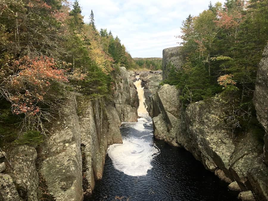
The Liscomb River hike is a loop trail that allows you to explore both sides of the river. Along the way, you will come across a stunning waterfall that can be viewed from a suspension bridge. You will also find a viewpoint of a fish ladder, which is used to help restock Atlantic salmon.
The trail is commonly used and can be easily hiked with proper footwear. It is well-marked and has several signs throughout to indicate lookout points. Since it runs along a river, there are plenty of great access points to the river. However, visitors should be aware that the trail can get quite muddy due to its proximity to the water.
For more information on the Liscomb River Trail, check out our article “Hikers’ Guide To The Liscomb River Trail System (NS, Canada)”.
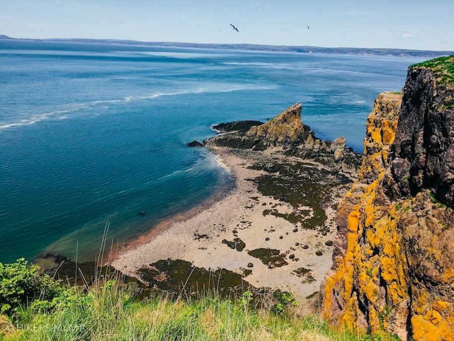
Gaff Point
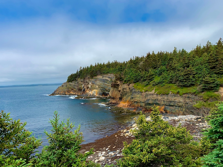
Kingsburg, Nova Scotia
Distance: 6.6 km (loop)
Time: 2-3 hours
Difficulty: Easy to moderate
Gaff Point is a popular hiking trail near Lunenburg, Nova Scotia. This family-friendly trail offers incredible views of the Atlantic Ocean and features varying terrain and a short beach walk.
The trailhead is easy to find thanks to clear signage and a map. The trail itself is quite wide and features helpful markers and signs that make it easy to follow. During your hike, you’ll encounter several bridges and move between forested and open coastal terrain. Finally, Gaff Point boasts a “hidden beach” that, while not as secret as it once was, is definitely worth a visit.
The trailhead is located roughly 1.5 kilometres down Hirtle Beach. This is the only way to access the Gaff Point trail. Therefore, the total distance of this hike includes Hirtle Beach. Initially, the beach has sand and then transitions into rocks before you finally reach the trailhead.
For more information on the Gaff Point Trail, check out our article “Hikers’ Guide To The Gaff Point Trail (Nova Scotia, Canada)”.